Saturday, November 17, 2012

Cam Farm area to Hawes

After a soggy and fairly uncomfortable night, we awoke to.... (drumroll, please)... clouds and fog.  Oh wait, did I mention the cold? Yeah, it was cold too.  Despite our attempts to find a flat spot last night, we ended up sleeping on a slope, a soggy slope.  Everything was wet, and we were not well rested.

It was no real surprise then that we started bickering early.  I believe comments were made about how one of us was "not walking properly" and "walking too heavily."  This caused the heavy walker to stomp off for a bit on her that person's own.  Chalk it up to lack of sleep and of dry clothes.  Fortunately, the nice thing about Chuck's and my friendship is that we never argue for long.  Movement soon lifted our spirits, as it usually does.  We both find walking to be its own form of therapy, although sometimes it's only temporary therapy. Still, relief even for a short period of time from the traps of your own fears and insecurities can be a blessing.
Muddy but happy walking
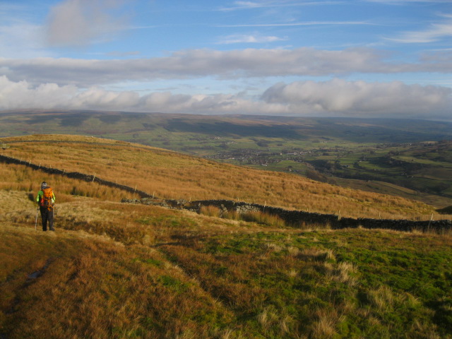
The area below us and to our left was called the Snaizeholme Valley and on our right was Dodd Fell. I fell to wondering where Snaizeholme Valley got its name.  Was it the home of a person named Snaize?   Holme is actually from a Middle English word (holm) which is derived from an Old Norse word  (holmr) and means small island.  I have no idea what Snaize might be.  But, the valley below looked nothing like a small island to me.  So much for etymology.  I'm going back to "the home of Mr Snaize."

Other than the trail itself, there were no blatant reminders of civilization to be seen - no buildings, no wires, no antennas.  Just lots and lots of hilly ground and limestone rocks.
Snaizeholme Valley
We knew the town of Hawes couldn't be far away because early in our day we'd been passed by three guys on motorcycles (who didn't look as though they were out for a lengthy journey), but for a while, we were on our own with Mother Nature.  And Mother Nature was apparently pleased with us because as we made our way around Dodd Fell, the sun came out.

Despite the sunshine, it was still cold and windy.  As we headed down Rottenstone Hill, we had to huddle by a stone wall while we took short snack break.  Rotten with mud, rotten with mire and muck, Rottenstone Hill was aptly named. The descent was a struggle. There was so much mud that with every step we went from slipping to sinking and back to slipping again.  By the bottom of the hill, I was so covered in mud, I wondered if I would ever be clean again.

Finally we reached the end of the rotten hill and emerged onto tarmac and grassy meadows on our way to the tiny village of Gayle (which didn't seem to be a distinct municipality from Hawes - they just blended together).  
Instructions provided for crossing the field
As instructed, we walked single file through the meadows to Gayle, after passing through an extremely narrow stile.  In fact, we had to go through a number of stiles that were clearly not intended for those with backpacks.  Chuck worried about me damaging my pack (which is actually his), but fortunately, the pack (and I) made it through unscathed.
How skinny are the people of Gayle?
As we entered Hawes, I realized we had arrived at my favorite town on the journey. Hawes is quaint and lovely -  cobblestone streets, old churches, tiny shops, a small bridge over a rushing river... oh, and at least four pubs within a block of each other.


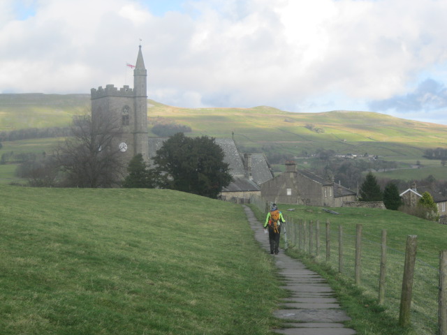
We made our way to our B&B, Ebor House.  Our hosts for the night, Stuart and Janie McLoughlin, were gracious and friendly. Stuart met us at the door, gave us a place to put our muddy boots to dry and even took the trouble to learn our names (a first on the trip).  Ebor House would be, in my opinion, the nicest B&B of the trip.

After a shower, we strolled around town, where we visited every outdoor gear shop we could find (and there were at least 4) in search of mittens for Chuck, stopped by a used book store (where we picked up some new reading material) and then found a place to have some lasagna for dinner.  Sated but exhausted, we returned to the comfort of our room and watched one of the DVDs the McLoughlins made available to guests - a new BBC version of Wuthering Heights.  It was all a little too "interpreted" and "artistic" for me, but Chuck at least got a sense of the story, and the images of the moors were all too familiar.  As I snuggled under the covers, I knew I would sleep well.

Friday, November 16, 2012

Horton-in-Ribblesdale to Cam Farm area

Our night at the Golden Lion Inn passed uneventfully.  The first view out of the window in the morning was of the church across the street, cloaked in grayness and fog.  With a graveyard in the front and some black ravens flying about, it was decidedly spooky.
Horton-in-Ribblesdale's ancient church
As was becoming typical on our journey, we were short on supplies.  It's hard to carry a lot of supplies when the only means of transporting them is your back. With the Pen-y-ghent Cafe closed and the other store referenced in our guidebook no longer in business, our chances to restock didn't look good.  We asked the chef who prepared our breakfast (who was also last night's bartender) whether there were any shops nearby.  He thought for a while and initially told us that we were out of luck. Our hearts sank... Then he remembered a little "mobile shop" and told us how to get to it. Little did we know how accurate his description would be.

We packed up and headed out in the direction we'd been given.  We were soon doubting ourselves and our friend, the chef.  The street we were told to turn down looked exclusively residential in nature.  We were both a little cranky, but somehow I persuaded Chuck to proceed on faith.  Sure enough at the end of the lane, there was a silver camper with "Mobile Shop" painted in red on it. There was a handwritten note on the door stating that the owner had gone to Settle (a nearby town with a strange name) to get bread and would be back in around 10:45/11:00.  Chuck was not inclined to wait.  He hates waiting even at the best of times, but in a town that smelled of chemicals and exhaust (which we assumed were from the quarry nearby) there seemed to be no point.  But I used all my charms to convince him we would be happier sticking around for a bit longer.
"I hate waiting!"
Fortunately for me, when the owner came back and we got a chance to explore the shop, it was (again) worth the wait.  Fresh fruit and veg, biscuits, dairy products, juices, the aforementioned bread, all the basic supplies were there.  Maybe the Mobile Shop didn't have quite the selection of Aladdin's Cave or Gordale Gifts, but we weren't in a position to be picky.  We stocked up (at least to see us through the next day or two)!!!

Somehow, even though Horton-in-Ribblesdale is at best a one-street town, we got a little lost on our way our of town.  We did get to see some lovely chickens living in the town park though.  I wondered what the townspeople did when they wanted to use the park for something other than providing chickens with a home. Maybe they just played a complex version of football that had obstacles in the form of chickens...


Eventually we figured out where we needed to go and started climbing back up into the hills.  We passed a lot of old, abandoned stone buildings and outcrops of limestone and even place called "Calf Holes."  The guidebook didn't say much about this stream/ mini waterfall other than "Calf Holes - Water falls into a sink hole." But it was scenic, so we stopped and looked for a bit. It was definitely pretty, but I couldn't figure out why there was a wall, a wire fence, and a stile to climb over to get down by the water. Chuck and I figured maybe it was for people wanting to picnic by the stream.  (I've since learned that the sink hole is a deep cave and people like to go spelunking in Calf Holes.)
Calf Holes
We didn't tarry long; there were still miles to go before we would sleep.  Ahead of us was a deep ravine called Ling Gill, with a beck (stream) flowing through it.  The Ling Gill area has been deemed a "nature reserve,"  and the signs promised landscapes and flowers and wildlife galore.  In November, the flowers and the wildlife are no where close to "galore."  But the scenery was beautiful.  I tried to take pictures to capture the allure of the gorge, but unfortunately, they do not really convey either the depth or the loveliness.
An unimpressive picture of an impressive place
Past the ravine we walked along the beck and over a bridge with an unintelligible stone plaque on it.  The guidebook told us that all it said was that the bridge had been repaired in 1765.
A very old bridge

Ling Gill Beck
If it was repaired in 1765, when was it built? Neither the book nor the bridge gave us any clues.  I had to content myself with imagining it to be over 500 years old.  Pretty amazing. Definitely older than anything in America. I've seen lots of old things in England, but this bridge out in the middle of nowhere sparked the imagination.  Why would they build a bridge here? What happened to the roads that must have led up to it?  Were there towns nearby that don't exist anymore? Who used the bridge?

Often times in my past I've thought that I should have followed my gut back in college when I wanted to quit studying physics.  Every year that I was in college I would have a minimum of one (and usually many) "what am I doing?" moments which would lead me down the path of exploring a different major. Sometimes I went and talked with other potential academic advisors. Sometimes, I'd just start planning out what other courses I could take. I actually started my senior year in college trying to figure out if I could switch majors and still graduate on time (mine was a school that didn't allow you to take more than 3 classes at a time or spend more than 4 years).  I wanted to become an anthropology major.  The sad thing was I had one required course outside of my major that I still needed to take in order to graduate, and this made me one course short of being able to major in anthropology.

I wonder, had I been able to persuade someone to let me take four courses in one term, would I have ended up doing something I could be passionate about, like maybe archaeology?  I suppose one could have switched from physics to archaeology in grad school, but anthropology to archaeology seems like they fit together a bit more naturally. I've always been fascinated by ancient cultures - Egyptians, Mayans, Incans, Celts, etc.  History is so inspiring to me.  How late is too late to start your life/career over?

Anyway, back to the Pennine Way, I contented myself with simply wondering about the bridge and its "life."  We were now walking towards an old Roman pathway, and we were supposed to be able to see the Ribblehead Viaduct off in the distance.  Of course, we would have no such luck with the views.  The fog and rain were descending again, and our view of the viaduct is below:
Can you see the hint of a structure way off in the mist? That's the Viaduct
How disappointing!!! I guess that's one of the reasons not to walk in November. We trundled on, and were soon on Cam High Road. It was nice to walk on pavement for a while. We passed a couple of girls, walking with their dog.  We asked them how they were, and their response was "sore."  Chuck and I replied politely, but as soon as they were past, we asked each other "Sore from what?"  Neither of us had experienced any soreness so far on the journey.  Was there something far worse than our worst climbs ahead of us?  The guidebook hadn't indicated so...  Oh well, perhaps they had climbed up from the valley floor to the path.

We were getting close to the end of the day. The mist was descending quickly and the rain was starting to come down.  The ground on either side of the road was decidedly damp and soggy.  We kept looking for a flat spot to camp.  Finally, with darkness approaching, we decided that the best we were going to do was to camp directly on the road in the corner of an intersection.  The intersection seemed to have been designed to allow cars or trucks to turn around in each of the corners. So, we picked the flattest and least puddle-ridden of the corners and set up the tent.  It would be a long and wet night...

Thursday, November 15, 2012

Just past Tennant Gill Farm to Horton-in-Ribblesdale

We awoke to fog and mist.  As this was more common than not, we simply nodded and grumbled at each other and got ready for another day of low visibility and wet clothes.  
A misty start to the day
Today was the day I had been dreading since I first started preparing for this trip.  I knew what lay ahead: Pen-y-ghent. Pen-y-ghent is a mountain and not just a hill, and the name means "hill of the winds."  The guidebook's description of today's trail had me worried: "A daunting climb with a series of steep rocky steps.." Great... just what I needed. 

I was worried about my knee (which had been "okay" yesterday); I worried about my legs; I worried about my lungs; I worried about whether I could even make it to the top; I worried that my lack of progress would make Chuck too cold.  The guidebook did show an alternate trail that would allow me to completely avoid the climb, and I was seriously considering it.  But, there was still walking to be done before I'd have to make that decision. So, with uncertainty in my mind, we set off; if we waited much longer, we'd have run back into the farmer's son from last night, and that would have been a little awkward!

The hill we were on, Fountains Fell, was full of little holes, tiny caverns, and nooks and crannies in general.  One of them looked so much like a Hobbit hole to me that I had to wonder again whether Tolkein had walked this area.
The inspiration for Bilbo's home?
As we walked over Fountains Fell, the fog seemed to show no intentions of lifting. In fact, it was getting heavier as we entered an area that was full of abandoned mine shafts. Signs warned us to remain on the path or risk falling into one.

Beware the mines!!!!
Nessie? No, it's a grouse.
As we trudged through the mist and the mud, we passed several large stacks of rocks/cairns. I was a little afraid to get too close to them in case there was some hidden mine shaft, although they were very intriguing.  Who spent the time to stack them so high and why would someone spend his/her time doing such a thing?    Was there a purpose to them beyond simply because the rocks were there?  The answer: Nobody knows.... (or at least that's all the answer I have)
Because they were there?
Fortunately, the only mine shaft that was really close to the trail was fenced off.  It did make me wonder, though, whether any of the wildlife in the area had accidentally fallen into some of these abandoned mine shafts.  I hoped that animals were smarter than humans and didn't need signs and fences to warn them about deep holes in the earth.

Finally, after we crossed over a stile, we emerged unscathed from our brush with mine-shaft-peril and left it behind us. Almost as soon as we did, the fog began to lift. We descended from Fountains Fell to blue skies with fluffy white clouds and walked along a narrow country road.  Chuck likes the image of a long and lonely road, and I have to say that I agreed with him today.  
We could see Pen-y-ghent off in the distance, and every step closer to it my anxiety level increased.  I didn't want Chuck to think I was afraid or even nervous, so I concentrated on the blue sky and tried to look completely calm (I'm sure he wasn't fooled for a moment because I spent quite a bit of last night telling him how nervous I was).  We stopped for a break right outside a car park (with an honesty box for payment).  I wondered whether many people actually put money in the honesty box.  I'd have to imagine that they did, otherwise, the honesty box would have long since been replaced with some type of payment monitoring system.  I suspect that if there was something like that in the US, most people would "conveniently forget" to pay.

We had a little contest while we sat - who can find the most interesting rock within arms' reach.  I won (of course), and it was really no contest.  Soon though, there was no more stalling. It was time to head for Pen-y-ghent. We'd made really good time in the morning on Fountains Fell, and so it wasn't even noon.  Lots of time to climb.  We could see tiny red and blue specks off in the distance, moving up and down Pen-y-ghent. As we got closer, it looked as though someone was running up and down the bottom two-thirds of the mountain.  I wondered who would voluntarily go up and down over and over - whoever it was was probably crazy.
Pen-y-ghent
As we got closer and closer to the base of the steep climb, I found myself lagging farther and farther behind Chuck.  I told myself I was just trying to take good pictures, but I knew I was afraid.  Chuck, as always, was supportive and encouraging, telling me it didn't matter how long it took. But, I was worried I wouldn't make it no matter how long I had!

The alternate route was fast approaching, but in the end, I chose to attempt the climb.  I was more afraid of trying to traverse the alternate path without a guide book.  (We had sent our second book back to Harrow when we were in Gargrave.)   So, despite the trepidation I felt, I prepped myself in the best ways that I could: I drank a lot of water, I unzipped my jacket and took off my hat, and I took several deep breaths.

I steeled myself and started counting my steps.  You may remember that this is my little "trick" to keep myself moving up, but before I knew it, I was about 1/3 of the way up and looking down at tiny people and the path I had just been on.
The view down

I found I was stopping because I was amazed that I didn't desperately need to rest. The path up was definitely steep, but my stops weren't really much longer than Chuck's, and he wasn't gaining too much ground ahead of me.

As you approach the middle third of the hill, it is literally strewn with limestone rocks and boulders. I was very glad that the path through the field of rocks had been cleared for us, and we simply had to deal with normal Pennine Way stone slabs/steps.

The final third of the climb would be the most challenging and the most terrifying for me.  Poles were no longer helpful.  We literally scrambled and clambered over the rocks.  I've never done any rock climbing,  and, as previously mentioned, I am not the most graceful of individuals.  So, there were a few spots, when looking behind me (and down) was not the best idea.  Fortunately, I finally emerged at the top without having developed acrophobia.  The exhilaration I felt was like nothing else.


Pen-y-ghent was the biggest challenge for me on the trail (as I would be leaving before any of the other high peaks).  I had been scared all day leading up to the climb, but in the end, the day climbing Laddow Rocks had been so much worse physically.  I know I have written previously about the sense of wonder I had been experiencing as I was able to do more and as I felt better each day on this trail.  Likely, you, the reader, are thinking, "I've already read this. She's amazed she can do this.  Hasn't she figured out yet that she has been getting fitter as she goes?"  I guess that it's hard to overcome the doubt of my physical abilities that has accompanied me most of my life. The changes in me had been so subtle (at least to me), so gradual that I remain astonished at each new feat.  Perhaps though, this was the day for it. I have never been prouder of a physical accomplishment (or at least of one of my physical accomplishments).  To me, this was like reaching the top of Everest  (granted, it was a very, very small Everest).

I took a moment to savor my triumph, but there was no time to rest.  Dozens of other walkers and hikers were approaching from all sides, which wasn't as much of an issue as the amount of wind on the top of Pen-y-ghent.  Time to start down towards Horton-in-Ribblesdale.  Now the momentary high was replaced with anxiety about my knee.  It was well-warranted, as the descent was brutal - steep, unforgiving, hard.  We saw a young man below us pelting down the path; he looked like someone running down a hill without full control of his pace or his limbs. Yikes!

Because of my knee the walk down took considerably longer than the climb up.  I had to rely on my poles before each step to take some of the pain away from my knee.  Finally, Chuck took my pack and carried it in front of him as he sped away down the path. I think his plan was to go ahead, find a spot to leave my pack, and then come back to either provide encouragement or, if needed, a shoulder to lean upon. I was grateful for the encouragement and thankfully didn't need the shoulder.
A look back...
The remainder of our walk to Horton was essentially over small rolling hills. I'd be so thankful for the ever-so-brief uphill sections and then curse the downhills. But, I couldn't curse the views. The countryside was gorgeous.  Again, I couldn't really believe we were half way through November. There was still plenty of green grass to be seen.
Limestone outcrop


Horton-in-Ribblesdale was not a fascinating town/village despite the impressive sounding name. We had been looking forward to stopping by the Pen-y-ghent Cafe, which was touted in the guidebook as being very walker friendly, but it was closed for the season. We couldn't even sign the guest book.  There was a sign on the door saying we could send them a letter to let them know we'd been through, and they could then note us in the guest book. We passed on that.  

We were now tired, what a surprise, and ready to be able to put our feet up. Although I'd tried to get a mobile signal throughout the day to make a reservation at a B&B, I'd had no luck. So, we sat in the parking lot of the Golden Lion pub and called to reserve a spot.  The lady asked when we thought we'd arrive, and I said "well, we're right outside now..."  Fortunately she was kind and let us check in right away... to the tiniest room ever!

There was barely walking space on either side of the bed and the TV was minuscule. But, we weren't going to complain. There was a bed and a shower and a pub downstairs where we could eat.  As I lay on the bed with my knees propped up, I had a big grin on my face. What a day!  

Wednesday, November 14, 2012

Malham to just past Tennant Gill Farm

Morning in Malham came too soon.  Our clothes were not completely dry from the massive dirt removal process we'd begun the night before. Unfortunately, as with most B&Bs, the radiators had been turned off at night when the landlord went to bed.  So, once he was up in the morning, we turned the radiators back on full blast, got the space heater working and headed down to breakfast.

We left around 10:30 and decided to see if there was any place to get some food. Once again, our supplies were running low.  There was nothing in Malham that would have classified as a grocery store, but there were 8 places to find accommodation, 6 eating establishments, 2 pubs, and 1 gift shop/outdoor supply store - total number of actual businesses providing all these things = 10.  I guess it pays to be multi-functional in Malham.

Of all of these businesses, the only one which even stood a chance of meeting our sustenance needs for the next days' hikes was the gift shop/supply store - Gordale Gifts and Outdoor Wear.  It wasn't open when we got there, and so we stood trying to peer into the darkened windows to see if it might possibly have food.  Chuck had broken a boot lace that morning, and it did appear that Gordale Gifts could possibly supply a replacement.  With some things at the back of the store that looked like they MIGHT be food, we decided it was worth waiting for the proprietress to open the shop at 11.
Waiting patiently...
We wandered around the village, such as it was, waiting for opening time and watching hordes of people preparing to go for a walk.  These people didn't appear to be Malham residents.  Some had arrived on a small red bus, but most were parking along the main (and essentially only) street in Malham, digging their walking apparel out of their boots - car boots and not hiking boots - and consulting various maps.  It made me excited for the day's walk. If this many people were coming to Malham in the middle of the week to walk, Malham Cove and what lay beyond must be spectacular.

Finally it was time to go back to Gordale Gifts, and it was definitely worth the wait. If Aladdin's Cave (back on day 7) had been an oasis, this was an oasis within an oasis! Gordale Gifts had its share of knick-knacks and souvenirs, and it also had lots of outdoor wear (as you would expect from the name of the shop), but the new owners had taken it one step further. They had made a point of asking their hiking clientele what they would want to purchase, and as a result, they had all manner of wonderful supplies for the walker: tent stakes, rain gear, gaiters, compasses, foam sit pads, all manner of small toiletries (individual disposable razors, for example), blister packs, camel backs... the list went on and on.
We were spoiled for choice.  Looking at the foam sit pads, I couldn't help but think of a line from my favorite movie of all time - A Room With A View - "Observe my foresight. I never venture forth without my mackintosh squares.  At any time one may have to sit on damp ground or cold marble." - Eleanor Lavish (played by Judi Dench).  Since damp ground was par for the course, of course we had to get the pads!

We left the shop after 11:30 and finally headed out towards Malham Cove.
As we got nearer and nearer, the rock formation just became more impressive. It is 260 feet high and over 1000 feet wide.  A small stream, Malham Beck, flows out from a cave at the base of the cove, and it seemed like a lovely spot for a picnic.  We had to climb about 400 stone steps to reach the top.  The climb was difficult for me, but I was amazed to notice that it wasn't nearly as hard as other climbs had been earlier in the trip.  I must be improving...

The top of the cove has been described as uneven limestone pavement.  This site was actually used to film a short scene in Harry Potter and the Deathly Hallows (Part 1) - Harry and Hermione apparate in and out in attempt to avoid the forces of evil.  But, there were no wizards popping in and out today, just beautiful landscape.


We idled our way through the limestone and the valleys. There were small caves and interesting rock formations to look at, and we passed some shaggy cows along the way.  Shaggy cows.... so cute!  Emerging from the limestone, the areas leading up to Malham Tarn were wide and expansive.
The tarn itself was pretty placid, but the winds around it were starting to pick up.  We were getting a little tired and hungry, but it was hard to find shelter near the lake, or at least shelter that wouldn't be more soggy than our new sit pads could handle.


We were also getting a little grumpy, and this led to a small spat over picture taking, the details of which are hardly worth recounting.  Suffice it to say that it was soon over, and we sat right in the middle of a gravel road to take a break and have a bite.
The view from our resting spot
All too soon, we were back on our feet, winding around Malham Tarn and walking along the tree-lined lanes past the Malham Tarn House Study Centre.  We were quickly back to walking through farms and thus through mud.  The time spent on lanes and roads was over too quickly, as I immediately sank ankle deep into mud, and our pace slowed.

We had about 3-4 miles of farmland trekking before we would finally stop for the night.  As the day progressed, the clouds got lower and lower in the sky.  The mists were starting to descend.
The last stretch took us right through a farm, Tennant Gill Farm.  It was the end of the day, and the farmer and his son were rounding up their animals - sheep and cows - for the night.  The son was riding around on a four-wheeler with his border collie following along, trying to find the last of the cows.  We located a camp spot along the trail but fairly close to where the farmer's son had just passed looking for cows.  We figured he'd be back later (and he was), and so we sort of stood around trying to look nonchalant as we waited for him to head home.  Finally he came back through with the dog now balancing on the back of his vehicle, and we set up camp for the night right in the middle of the trail.  We huddled into our sleeping bags, broke out our new purchase (a book by Alfred Wainright, A Pennine Journey), and passed the hours from dark until sleep with reading about someone else's travails on the trail. 

Tuesday, November 13, 2012

East Marton to Malham

Last night was a rough one for Chuck.  Something he ate did not agree with his stomach, and he was up and down (and in and out of the tent) all night. I blame the brussel sprouts he insisted on eating with his lasagna (in fact, he buried them in his lasagna to disguise the taste).  His unsettled stomach and digestive issues were pretty much finished by the time we were ready to leave our campsite.  Well, we weren't really ready to leave, and we debated not even walking along the Pennine Way to the next town.  We thought that maybe we could just continue along the towpath.  But, we had no map of it, and no guarantee that it would continue all the way to Gargrave, and so we decided we should stick with the original plan. We'd save the Leeds-Liverpool canal for another trip.

Finally we set off, and immediately we were back to farmland again.  The first field we walked through had cows that were so strangely colored, I almost thought they had been painted. 
I've seen a lot of cows over the years (I grew up in Iowa), but I'd never seen striped cows.  I had to take a few pictures just to prove I saw them.  I wondered a little how this type of coloring came to be - genetically or evolutionarily - but the only answer I could come up with was "nobody knows" (at least for now).  The cows left us to our walking, and we left them to their grazing.

Our walking quickly devolved into slogging (I'm sure the cows' grazing suffered no such problems). As we approached the stile at the bottom of the field, the mud just got wetter and, well, muddier.  There was no point trying to avoid it.  We just went straight through it.

Will I ever be dry or clean again?
But, despite the mud, the scenery was splendid.  We passed through wooded lanes and along quaint little roads.


Soon we reached Gargrave.  We planned to find the post office in town and send some of our more foolishly-selected items home: umbrellas, sunglasses, the camping stove (who can cook when it's always raining), etc.  Chuck was consulting the guidebook to determine which way we needed to go, and he informed me that soon we would be passing a pub called "Mah Son's Arms" (which I've spelled semi-phonetically for full effect).  He started to make a little speech about the funny names they use for things in Britain when I realized what he was saying. I had looked at the guidebook on the way into town, and I remembered the name of the pub.... "You don't mean 'Masons Arms' do you?" I asked and dissolved into laughter. Chuck quickly started to explain that the guidebook had a space between the "a" and the "s" and then decided it was better to blame his lack of reading glasses, but it was a little difficult to hear him - I was laughing too hard!
A full five minutes later, I had composed myself enough to allow us to continue on into Gargrave.  We found the post office, packed up a small box of things and sent them back to Harrow, and then restocked some supplies at the local Co-op store.

Before continuing on our way to Malham, we decided to stop to have something nice and warm, maybe a late breakfast. After our adventures yesterday, there was no way we were heading out without full bellies, plenty of water and maybe some more supplies. We ended up at the Dalesman Cafe.  Inside, we encountered two men, one in his 70s and one in his 80s, who were bicyclists.  Chuck settled into a happy conversation with them about all things "bike" while we ate breakfast.  I didn't have much to contribute to that conversation, but I was happy to watch Chuck enjoying himself.  I sat in the warmth and reflected.

A fingerpost (which is a type of signpost in the UK) outside of the cafe told us how far we'd come from Edale - 70 miles - and how many miles were left to get to Kirk Yetholm (the end of the Pennine Way).  I wasn't interested in how far we had to go to finish (186 miles).  I was frankly just astounded with myself.  I walked 70 miles... SEVENTY MILES!!! I don't think that I had really believed I would actually be able to walk this far, much less feel like I could walk farther.  
SEVENTY MILES!
I still had a week and a half left on the trail, and I wasn't exhausted.  I didn't feel terrible. If anything, I felt pretty good. Aside from the knee pain two days before, I physically felt maybe even better than good.  I couldn't remember the last time I felt this "alive."

Being athletic is not something that has ever come naturally to me, but boy did I wish it would have when I was younger.  I was always good in school; although I enjoyed the process of learning, it wasn't particularly difficult for me, and thus I had the previously-mentioned (see day 10) need for intellectual challenge.  Challenge in any form brings a kind of thrill that is hard to beat.  When I was younger, the biggest challenge I could find was for me was to overcome my God-given lack of athletic ability.  And it wasn't just a lack, I was clumsy and awkward in the extreme (I still can be).  I started playing soccer in 10th grade, and I played all through college (at a Division 3 school).  When I got to grad school, I switched to bike riding.  But none of it was easy, and although I know that athletics are not supposed to be "easy" for anyone, I'm sure I never made it look easy either.

But I couldn't handle the athletic challenge for long periods of time.  It was too...challenging. When the season was over, I was not one who would be constantly trying to improve my skills for the next season. I would be tired and ready to rest for a while. It took 5 seasons of soccer for me to finally "get" it. I remember clearly the day I could actually see how a play should go, where I should kick the ball, how to feint to get around an opponent. It was exhilarating, but it took so long to get there. My only real strength is that I can endure. I keep going. I may have raced behind the pack of cyclists and by myself for the entire race, but I managed to stay approximately the same distance behind them for most of the race.

Walking is about endurance, or at least I think it is.  If you can keep putting one foot in front of the other, you can walk a long trail. It may be slow going, but as Chuck is always telling me, the slower the better.  Anyway, as he and his two new friends discussed the world of cycling, I was reflecting on how maybe I wasn't the worst walker in the world and about how good this walk made me feel to do it.

Eventually, we knew we had to move on to Malham.  We shouldered our packs, zipped up our coats and headed back out into the countryside.


Sated and satisfied from our stop in Gargrave, the couple of miles of farmland and moor passed quickly and uneventfully. We chatted away and strolled through England without a care in the world.

About three miles from Malham, we encountered the River Aire (again).  We had first crossed it in Gargrave, but we would not leave it again today.

There is nothing quite like meandering alongside a river. Even in November. I think I will always remember this part of this day as one of my favorites.    The only thing that could possibly spoil the experience was the ever-increasing amount of mud.  And it was really increasing.  The mud was  well above my knees on the insides of my pant legs.

We knew we were close to Malham, and for some reason, we were worried about how we'd look to our B&B landlord. So, several times during the remainder of the day, we stopped by shallow spots in the River Aire. We walked right into the water, trying to wash as much mud off our boots and clothes as we could.  The water was frigid, but it seemed important to be less muddy.  Here are a few more of pictures of our lovely river walk:

You can see the muddy path.


We continued on, sometimes right next to the river, sometimes up in the hills just above it, but never leaving it.  As we crested a hill, we finally caught a glimpse of Malham and Malham Cove right behind it.
Malham in the distance
We stopped for a short rest on a hill overlooking the landscape.  My knee was starting to plague me again, and I worried that it was a more serious injury than I might want to admit.  Chuck told me to just take it slow and reminded me that it didn't matter how long it took us to go the last mile to our B&B (Miresfield Farm - an appropriate name).

I followed instructions and just as it was starting to get dark, we reached our destination.  The landlord took one look at us and offered to rinse us off with a hose (this was despite no fewer than 3 attempts to get clean in the river).  Somewhat less muddy, we headed up to our room and began our nightly ritual of drying most things and rinsing some things out.